QUICK SEARCH
MO PROJECTS:
Africa
Asia/Pacific
Mesoamerica
North America
South America
General Taxonomy
Photo Essays
Training in Latin
America
MO RESEARCH:
Wm. L. Brown Center
Bryology
GIS
Graduate Studies
Research Experiences
for Undergraduates
Imaging Lab
Library
MBG Press
Publications
Climate Change
Catalog Fossil Plants
MO DATABASES:
W³MOST
Image Index
Rare Books
Angiosperm
Phylogeny
Res Botanica
All Databases
INFORMATION:
What's New?
People at MO
Visitor's Guide
Herbarium
Jobs & Fellowships
Symposium
Research Links
Site Map
Search
Plant Conservation Assessment in the Eastern Arc
|
|||||||||||
| Home Page | Project Overview | List of Targeted Plant Taxa, Explanation |
List of Targeted Plant Species, Subspecies and Varieties, and links to Conservation Data |
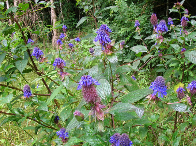 Mountains, Tanzania Photo by Sharon Bodine |
|
|
Point cursor on image for full caption
|
|
We here present the List of Targeted Plant Species, Subspecies, and Varieties in the study region, with live links to the TROPICOS database for all of the taxa (in this case, the species, subspecies, and varieties) for which comprehensive specimen data have been compiled.
This link goes directly to the Nomenclatural Data Base page for each taxon. These collection data are all available here through the “Specimen lists and maps” button on this page.
Proposed Red List assessments of these taxa are posted in TROPICOS as they become available, through the red “Published Conservation Status” button . The supporting data for these proposed assessments, including distribution maps and summary Red List Assessment parameters, are also posted in TROPICOS in the “Images” menu: here, highlight “Distribution Map” then click on “SUBMIT” to display these supporting data.
The supporting data include distribution maps and several calculated parameters. The information here is coded as follows (see the sample images of Isolona cauliflora and Sanrafaelia ruffonammari below):
» the light and dark green colorings indicate legally protected areas;
» red shading indicates elevation, from light shading for lower to darker shading for higher elevation;
» light blue dots are specimen localities;
» dark blue dots are visual records (these records are not documented by a specimen,
and are not included in calculations of parameters);
» the area of the polygon connecting the dots is the Extent of Occurrence (EOO);
and
» the combined area of the red grid cells around the specimen localities is the
Area of Occupancy (AOO).
Note that the scale of each species map differs, depending on the distribution range; latitude
and longitude may not be indicated on maps of species with limited distribution. For additional
information about the significance and calcuation of the EOO and AOO, see the IUCN Red List Categories and
Criteria
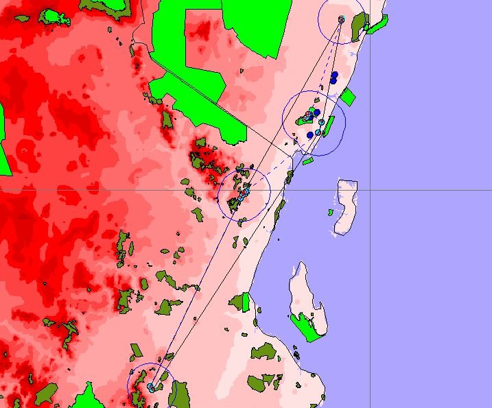 Isolona cauliflora
|
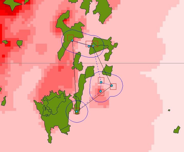
Sanrafaelia ruffonammari |
In addition to these analytical maps, standardized world distribution maps can also be generated for each taxon in TROPICOS. To see these, click the “Specimen lists and maps” button, then choose one of the mapping options: “Discover Life Global Mapper”, “MBG map”, or “Google Maps”.
Compilation of this List of Targeted Plant Taxa
Early in the preparation of the Plant Outcome Definition Database for the CEPF Eastern Arc Mountains and Coastal Forests, Quentin Luke and Roy Gereau realized that the coverage of the area in the IUCN 2002 Red List of Threatened Species was woefully incomplete, with only 236 species of vascular plants listed as globally threatened. At this point they began to compile a List of Potentially Threatened Plants in the Eastern Arc Mountains and Coastal Forests (EACF), that is, a list of plant taxa (species, subspecies, and varieties) occurring in the EACF whose threat status had not been assessed, but which may be under threat of extinction.
Criteria for inclusion in the List of Potentially Threatened Plants in the EACF include restricted geographic range, overall rareness throughout the geographic range (whether highly restricted or not), extreme habitat specialization, and occurrence in habitats or localities under great environmental stress. Sources of information on species and their distribution include the Flora of Tropical East Africa and other published floras, taxonomic monographs and revisions, the TROPICOS database of the Missouri Botanical Garden, and Quentin Luke’s specimen database.
This List of Potentially Threatened Plants in the EACF was combined with the 236 species from the IUCN 2002 Red List of Threatened Species to form the List of Targeted Plant Taxa in the EACF that forms the basis for the Red List assessments being conducted by this project. The list is continuously updated as new information becomes available from publications, specimen collection records, and input from taxonomic specialists.
The List of Targeted Plant Taxa for this project now contains 1,743 species, with 2,128 total taxa (species, subspecies, and varieties). This represents more than a quarter of the estimated 6,500 vascular plant species in the EACF, and approximately 15% of the estimated 11,500 species in Tanzania and Kenya combined.
This page was created 09/12/07.
© 1995-2025 Missouri Botanical Garden, All Rights Reserved
4344 Shaw Blvd.
St. Louis, MO 63110
(314) 577-5100
Technical Support