Madagascar topography map
Click image for enlargement
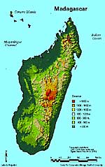
Topographic map of Madagascar. From the east coast the land rises rapidly behind a narrow coastal plain to elevations of 3000-5000 ft. at the edge of a hilly plateau which occupies the whole central part of the island. The plateau slopes off gradually to the west and is the base for a few volcanic uplands, the highest of which reaches an elevation of 9450 ft/2880 m.


|
Contents:
1.Spiral millipede
2.Crowned Lemur
3.Locator map
4.Gondwanaland United map
5.Gondwanaland Separation map
6.Madagascar topography map
7.Ankarana tsingy and Pandanus
8.Madagascar
natural vegetation map
|