QUICK SEARCH
MO PROJECTS:
Africa
Asia/Pacific
Mesoamerica
North America
South America
General Taxonomy
Photo Essays
Training in Latin
America
MO RESEARCH:
Wm. L. Brown Center
Bryology
GIS
Graduate Studies
Research Experiences
for Undergraduates
Imaging Lab
Library
MBG Press
Publications
Climate Change
Catalog Fossil Plants
MO DATABASES:
W³MOST
Image Index
Rare Books
Angiosperm
Phylogeny
Res Botanica
All Databases
INFORMATION:
What's New?
People at MO
Visitor's Guide
Herbarium
Jobs & Fellowships
Symposium
Research Links
Site Map
Search
THE CLASSIFICATION OF NATURAL AND |
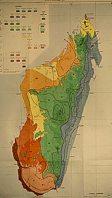 |
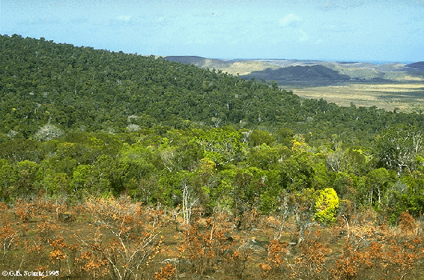
Much work remains to be done before such an approach can be implemented in Madagascar, although the recent progress in botanical inventory work (now mostly being conducted by local collectors) and systematic studies by Malagasy and foreign botanists, is certainly encouraging. We can, however, already formulate a few ideas of what the application of White's basic approach might tell us here in Madagascar. Cornet (1974) developed a bioclimatic map that clearly shows the presence of highly localized climatic conditions in several parts of the country, including in the transition zone around Vohemar located between the humid east coast and the dry north of the island, an area that corresponds precisely to a restricted zone containing a number of locally endemic plant species. Similarly, the transition between the humid east coast forest and the dry south to the west of Fort Dauphin, as shown here at Parcel 3 of the Andohahela Strict Nature Reserve, harbors numerous endemic species including Dypsis decaryi.
 |
|
Cornet's map also shows a specialized local climate around
Morafenobe, where a disjunct area of true evergreen forest occurs
at Ambohijanahary Special Reserve, with many species that are otherwise
restricted to the eastern part of the country. The application of White's
approach to Madagascar would also
result in treating all evergreen forests as a single broad
physiognomic category -- whose distribution, largely coincides
with the humid and subhumid stages indicated in blue and green on
Cornet's map. Reliable chorological information would then potentially allow us to differentiate floristically distinct zones within these
evergreen forests. If the ultimate goal of classification and mapping is to reveal
biogeographic patterns in order to recognize and delimit areas
that are biologically distinct, then chorology clearly must play
a central role. This certainly appears to be the case in
Madagascar, where one of the most important applications of a
vegetation map is for conservation planning.
© 1995-2025 Missouri Botanical Garden, All Rights Reserved
4344 Shaw Blvd.
St. Louis, MO 63110
(314) 577-5100
Technical Support