QUICK SEARCH
MO PROJECTS:
Africa
Asia/Pacific
Mesoamerica
North America
South America
General Taxonomy
Photo Essays
Training in Latin
America
MO RESEARCH:
Wm. L. Brown Center
Bryology
GIS
Graduate Studies
Research Experiences
for Undergraduates
Imaging Lab
Library
MBG Press
Publications
Climate Change
Catalog Fossil Plants
MO DATABASES:
W³MOST
Image Index
Rare Books
Angiosperm
Phylogeny
Res Botanica
All Databases
INFORMATION:
What's New?
People at MO
Visitor's Guide
Herbarium
Jobs & Fellowships
Symposium
Research Links
Site Map
Search
A View from the TopUsing Aerial Photography to Measure Madagascar’s Littoral Forests
Preliminary work conducted at a few sites clearly shows that littoral forests harbor many locally endemic species and high overall levels of botanical diversity. However, the distribution and size of the remnant patches, their floristic composition, and the geographic ranges of the constituent species, can only be guessed at currently, despite the obvious importance of such data to conservation planning, comparative ecological study, etc. Deforestation in eastern Madagascar has been most rapid in areas with low topographic relief. A recent prediction based on inferences from satellite images indicates that, at present rates of loss, humid forests will be restricted to only the very steepest slopes by 2025 (Green & Sussman, 1990). The eastern littoral forest, which biogeographically corresponds to sites near sea level on sand within Madagascar’s humid bioclimatic region, is one of the most highly threatened and impacted vegetation types in the country, and is almost surely condemned to extinction unless immediate steps are taken to preserve it. Recent field experience of the PI and Co-PIs at several sites supports this grim prediction. For example, at the Manombo Special Reserve, one of only three parcels of littoral forest currently with protected status, exploitation of timber for housing and fuel wood has left the forest in a severely degraded state. Similarly, littoral forest blocks at Mandena, N of Ft. Dauphin in extreme SE Madagascar, are being degraded very quickly by local charcoal producers, and only a few parcels are likely to survive beyond the next few years. Du Puy and Moats' map of estimated remaining primary vegetation in Madagascar shows clearly that very little of the eastern littoral forest remains in an undisturbed state. Only 11 patches are mapped along the entire length of the island, with a total area of no more than ca. 450 km2 (see their histogram, p. 216). If one makes the conservative assumption that littoral forest once occupied an area averaging 3 km in width along the ca. 1,500 km of coastline between Vohemar and Ft. Dauphin, i.e., an area of ca. 4,500 km2 (or only 0.77% of the total land area of Madagascar), then at most 10% of the original eastern littoral forest remains intact today. This is in fact probably an overestimate given that in many areas the littoral forest extends (or once extended) 5 km or more inland from the coast. Moreover, the data used by Du Puy and Moat are derived from satellite images dating from the 1970s and their calculations of remaining forest cover are therefore almost certainly overestimates. In any case, their statement that "The highly restricted Coastal Forest (Eastern) is an outstanding example of a vegetation type under imminent threat and without adequate protection" is more than amply justified. Examination of the patches of littoral forest that appear on a digitized version of their map, some of which are barely discernible, reveals only a few, tiny, additional sites.
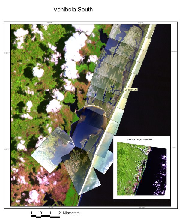
The precise number of vascular plant species that occur in Madagascar’s littoral forest habitats is unknown, but a conservative estimate would be ca. 1,200 species, out of ca. 12,000 total in the Malagasy vascular flora. In a recent study of ten 1-hectare plots established at five sites along the E coast, 358 species with a dbh ?10 cm were inventoried. By comparison, a total of 4,220 woody species with a smaller dbh ? 5 cm are known from the entire Malagasy flora, suggesting that the littoral forests as a whole may contain an impressive 10% or more of the total flora, despite their extremely limited and fragmented distribution. The floristic composition within the small amount of remaining eastern littoral forest on sand is also highly distinctive, with numerous endemic species and several genera. A survey of 20 selected families for which recent taxonomic revisions are available, together representing ca. 15% of the total Malagasy flora, indicates that at least 77 species in these families appear to be endemic to littoral forests. Of these, 37 are at present known from only a single site, an additional 18 are restricted to either the northern or southern half of the E coast, and 22 are found at two or more localities spanning the northern and southern zones. Likewise, a detailed analysis of genera in Madagascar’s endemic families shows that littoral forests, despite their small total size, figure prominently among the most important sites for local endemism, diversity, and the presence of large numbers of threatened species. Perhaps 5-6% of the Malagasy flora as a whole may thus be strictly endemic to littoral forest habitats, including a large number of species of critical conservation importance. We are conducting a comprehensive botanical survey of Madagascar's endangered eastern littoral forests utilizing digital aerial imagery, historical collections, and new collections generated from intensive field studies at several sites spanning twelve degrees of latitude. A preliminary list of ca. 45 littoral forest sites was compiled from available maps and specimen data. However, because much of the information on which it is based is now decades old, it is necessary to assess the current distribution, size and apparent level of intactness of stands along the E coast in order to select appropriate sites for the proposed inventory work. This was done by flying over the entire coastline from N of Vohemar (ca. 13°S) to S of Ft. Dauphin (ca. 25°S) using a light aircraft equipped with a mounted digital camera connected to a GPS unit to enable precise geo-referencing of remnant littoral forest stands. Six priority sites have been selected as follows:
In order to compile the remaining data needed for building a comprehensive list of vascular plant species currently known from littoral forests, a survey is being made of all available sources not yet examined for the Madagascar Conspectus Project. These include several published treatments in the Flore de Madagascar, and a number of taxonomic revisions, monographs, and other relevant works. Additional data from littoral forest collections is being captured from these sources, and a preliminary littoral forest species list will be generated. Specimen data is being entered at TAN, TEF and P for all material belonging to these species, and collections of all other taxa at the herbaria in Madagascar will be searched for possible additional records from littoral forests (it will not be possible to do this at P due to the very large number of their holdings). The new data supplements the ca. 6,000 records already available in the Missouri Botanical Garden’s TROPICOS database. In order to ensure comprehensive sampling of plant species, with a high proportion of material in flower and/or fruit, each site is being visited a minimum of four times during the 3-year duration of the project, with one trip scheduled in each quartile of the year to ensure seasonal representation. Standard collecting techniques used at MO, which have proven highly effective, are being used to sample vascular plants and mosses. A minimum of four duplicate specimens is prepared for each gathering, and sets will be distributed as follows: 1) TAN or TEF - depending on the taxonomic group; 2) MO; 3) the specialist working on the particular group in question; and 4) P, which has the largest and most comprehensive collection of Malagasy plants in the world. In most cases several additional sets are also being made for exchange with other herbaria interested in the Malagasy flora (including the California Academy of Sciences, Royal Botanic Gardens, Kew, and U.S. National Herbarium, Smithsonian Institution). Precise geo-position is recorded with a GPS unit, and detailed notes are prepared on each species (habit, size, flower/fruit color, etc.) and on the habitat in which it was collected. In addition, leaf samples of selected species (especially in endemic families and genera) will be preserved in silica gel for DNA extraction, and will be made available through MO's DNA Bank. In addition to the primary results generated by the proposed work (identified collections, published descriptions of new species and synoptic revisions, comprehensive floristic lists accessible on-line, and an substantially improved understanding of species diversity and endemism within Madagascar’s littoral forests), the data generated will also be used to assess the current extent of the remaining littoral forest patches and to identify the largest and least impacted ones. The Missouri Botanical Garden, in collaboration with ANGAP (l’Association pour la Gestion des Aires Protégées) and ONE (the Office National de l’Environnement), will use the results to evaluate patterns of species distribution among littoral forest taxa in order to identify sites/regions of especially high species richness and endemism as well as concentrations of threatened taxa, and to evaluate species turnover along a latitudinal gradient. This information will provide a reliable basis for more detailed ecological analyses and general biodiversity studies, as well as for conservation planning and management. In the past, identification of priority sites in Madagascar for the establishment of new protected areas has mostly been based on the assumption that species composition within a given vegetation type is uniform, and that selection of the largest and least degraded site(s) offer protection of most or all of the biodiversity. Results from this study will allow us to test this hypothesis of floristic uniformity along a latitudinal gradient, and if it is not supported (as would suggest the distributions of many species), we can then propose specific scenarios for the conservation of species-level diversity in littoral forest habitats by establishing new protected areas at key sites along the E coast. It will be possible, for example, through an analysis of complementarity, to calculate how many species would be conserved under a range of options involving protection of various sites, and to compare the effectiveness of each scenario for protecting total species diversity, littoral forest endemics, remaining populations of threatened taxa, etc. |

© 1995-2025 Missouri Botanical Garden, All Rights Reserved
4344 Shaw Blvd.
St. Louis, MO 63110
(314) 577-5100
Technical Support