QUICK SEARCH
MO PROJECTS:
Africa
Asia/Pacific
Mesoamerica
North America
South America
General Taxonomy
Photo Essays
Training in Latin
America
MO RESEARCH:
Wm. L. Brown Center
Bryology
GIS
Graduate Studies
Research Experiences
for Undergraduates
Imaging Lab
Library
MBG Press
Publications
Climate Change
Catalog Fossil Plants
MO DATABASES:
W³MOST
Image Index
Rare Books
Angiosperm
Phylogeny
Res Botanica
All Databases
INFORMATION:
What's New?
People at MO
Visitor's Guide
Herbarium
Jobs & Fellowships
Symposium
Research Links
Site Map
Search
Photo Essay Photo Essay |
| Photo Essay Home | Introduction | Outline | Photo Gallery | Search |
View Larger Image 25k |
Photographer: Unspecified Photographer
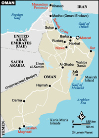
Oman occupies the eastern corner of the Arabian Peninsula, bordered by the United Arab Emirates (UAE) to the north-west, Saudi Arabia to the west and Yemen to the south-west. Oman's diverse geography includes rugged coasts, placid beaches, craggy mountains, salt flats, oases and deserts. The northern coastal strip along the Gulf of Oman is known as the Batinah coast, a sand and gravel plain separated from the rest of the country by the Hajar Mountains. The highest peak is Jebel Akhdar ('green mountain') at 2980m (9775ft). Oman also has two large areas of salt flats, one in the central west and another opposite Massirah Island, off the eastern coast, and just south of the popular Wahiba Sands desert area. Much attention has been devoted to the country's plant life: coastal areas are preserved and there are National Protected Areas scattered around the country. [Introduction and map from Lonely Planet: www.lonelyplanet.com/] |
||
|
|
© 1995-2025 Missouri Botanical Garden, All Rights Reserved
4344 Shaw Blvd.
St. Louis, MO 63110
(314) 577-5100
Technical Support