QUICK SEARCH
MO PROJECTS:
Africa
Asia/Pacific
Mesoamerica
North America
South America
General Taxonomy
Photo Essays
Training in Latin
America
MO RESEARCH:
Wm. L. Brown Center
Bryology
GIS
Graduate Studies
Research Experiences
for Undergraduates
Imaging Lab
Library
MBG Press
Publications
Climate Change
Catalog Fossil Plants
MO DATABASES:
W³MOST
Image Index
Rare Books
Angiosperm
Phylogeny
Res Botanica
All Databases
INFORMATION:
What's New?
People at MO
Visitor's Guide
Herbarium
Jobs & Fellowships
Symposium
Research Links
Site Map
Search
Photo Essay Photo Essay |
| Photo Essay Home | Introduction | Outline | Photo Gallery | Search |
View Larger Image 28k |
Photographer: Unspecified Photographer
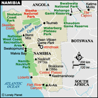
Namibia is on Africa's south-west coast, bordering South Africa in the south, Botswana in the east, and Angola in the north. The country is largely arid, but encompasses broad geographical variations and is usually divided into four regions: the Namib Desert and Coastal Plains along the coast; the scrubby, eastward-sloping Central Plateau; the Kalahari sands along the Botswana and South African borders; and the dense bushveld (woodland) of the north-eastern Kavango and Caprivi regions. The Namib Desert, the world's oldest arid region, has been around for over 80 million years. It extends along Namibia's entire Atlantic coast. Namib landscapes range from the mountainous red dunes in the south to the centre's interior plains and flat-topped, steep-sided, isolated mountains called inselbergs. The desert is scored by a number of rivers that rise in the Central Plateau but seldom carry water. East of the desert, the altitude increases and the dunes give way to gravel plains. [Introduction and map from Lonely Planet: www.lonelyplanet.com/] |
||
|
|
© 1995-2025 Missouri Botanical Garden, All Rights Reserved
4344 Shaw Blvd.
St. Louis, MO 63110
(314) 577-5100
Technical Support