QUICK SEARCH
MO PROJECTS:
Africa
Asia/Pacific
Mesoamerica
North America
South America
General Taxonomy
Photo Essays
Training in Latin
America
MO RESEARCH:
Wm. L. Brown Center
Bryology
GIS
Graduate Studies
Research Experiences
for Undergraduates
Imaging Lab
Library
MBG Press
Publications
Climate Change
Catalog Fossil Plants
MO DATABASES:
W³MOST
Image Index
Rare Books
Angiosperm
Phylogeny
Res Botanica
All Databases
INFORMATION:
What's New?
People at MO
Visitor's Guide
Herbarium
Jobs & Fellowships
Symposium
Research Links
Site Map
Search
THE EXPEDITION TO APOLOBAMBASummaryThe expedition lasted three weeks (April 16–May 6), during the southern hemisphere fall. We worked in three different locations along the road Charazani–Apolo between 800 y 2500 m elevation, in the Integrated Management Area of the Apolobamba National Park (IMA). The principal objectives were to make quantitative inventories for Alfredo Fuentes doctoral thesis in an area that so far has not been studied in detail. We evaluated eight different types of forest, for which we were completely lack information, in the montane seasonal forest and the upper subhumid subandean seasonal forest. We collected 1200 vascular plants and 60 mosses and made 32 quantitative inventories in primary forest and five in secondary forests. We collected a specimen of a Columelliaceae that was not know in the region previously, several fertile Lauraceae previously collected sterile in other inventories and Barnadesia woodii that until now was only known from the type.
PersonnelThe expedition was led by Alfredo Fuentes with the collaboration of Fabricio Miranda, thesis student in the project, Rubén Huanca and Pamela Mollinero, volunteers from the agronomy school in La Paz. We were further accompanied by Ramiro Cuevas, Ever Cuevas y Honorio Pariamo experienced guides who regularly works with us in the field. The expedition…We arrived in a four wheel drive LandCruiser rented with chauffeur from a company that travels this route on a routinely basis. The road in the Apolobamba IMA follows for the most parts the rivers Charazani and Camata in the deep valley surrounded by high mountain ridges. Locality 1: Seasonal Montane Forests
We first installed the quantitative study plots, and then we collected generally in the area between 2000–2500 m, an elevation where few studies has been done so far in the region.
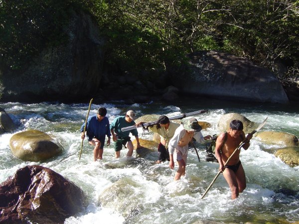
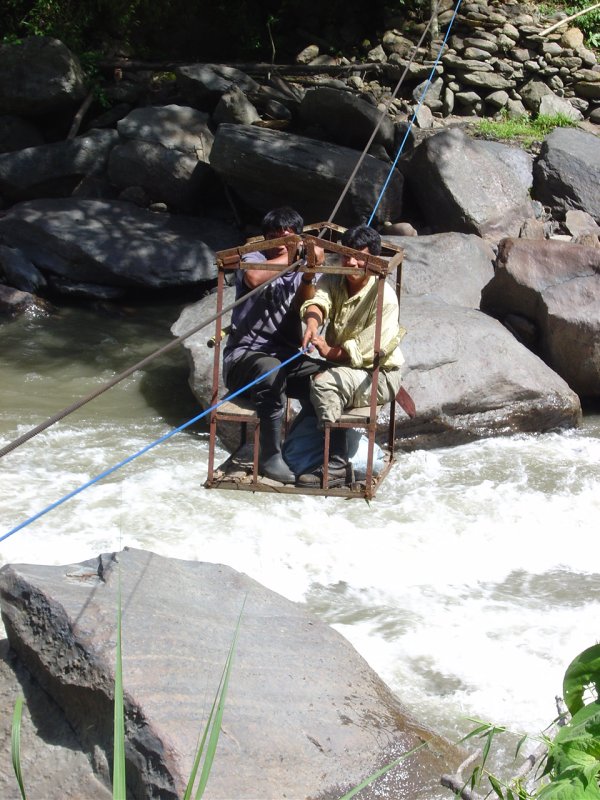
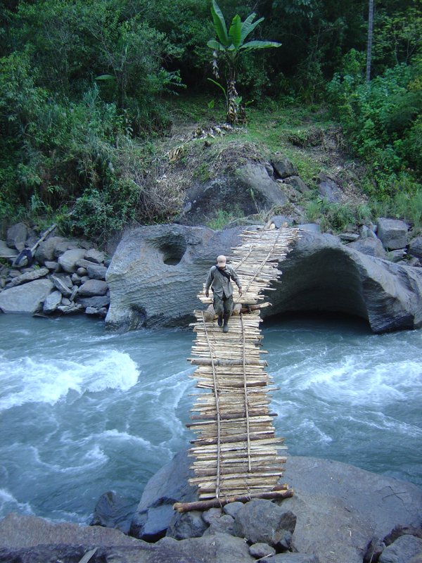
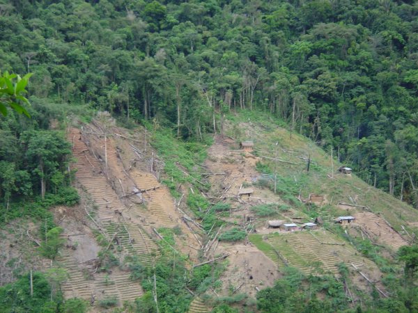
This elevation has in many areas been completely transformed through human activity stemming back from pre-Colombian times, the forest are today restricted the steepest slopes in some places we had practically to climb the bluffs and in others we had to cross the strong currents of the Charazani or Camata River on foot or with the help of the cable bridges locally called “maromas”. The access to the other side, where the grass is always greener, was difficult because of the lack of fords and well constructed bridges.
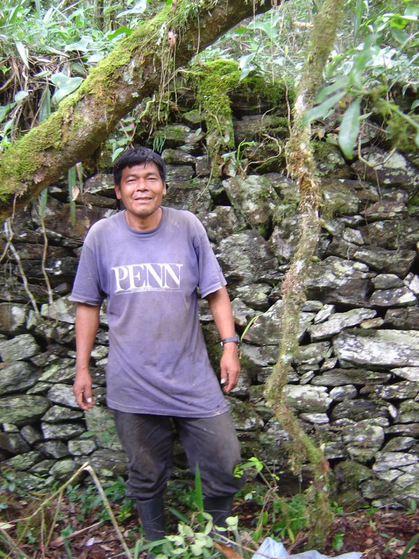
They are made by the people in the area and without doubt civil engineers were not consulted. It requires a cool head and no fear of heights to cross the flimsy wooden trunks that constitutes the bridges surface. What will they do when there are no more trunks to repair and maintain the bridges? The forest are composed by small trees and shrubs particularly of the genera Hedyosmum, Miconia (several species), Berberis, Columellia, Duranta and Nectandra, frequently with large entanglements of the Andean bamboo Chusquea in the more open areas, and ferns and mosses dominates the under story. In a remnant of forest near the Carpa community the dominating species belonged to Lauraceae and Myrtaceae a surprising composition that may indicate a similarity to the “Myrtaceae forests” from cooler climates of the Tucumano–Bolivian forest south of the knee of the Andes. The people living in the area belong to the Quichuas language group. The main urban settlements and larges population densities are found in the cities of Camata and Chrarazani located at the limit between Puna and the dry to humid valleys of the Yungas Bolivianos. Currently there is a constant slow migration towards unoccupied or less occupied areas at lower elevation; they open up fields on very shallow rocky soils clearing the forest even on the steepest slopes that are very inapt for agricultural purposes. Locality 2: Seasonal subAndean ForestsThe second locality was located is seasonal subAndean Forest at 1200–1700 m elevation. The preservation of intact vegetation was also here difficult to find and in almost all the sites we could access we found clear indications of alterations. To our surprise we found several “pircas” or human constructed rock walls up to about 2 m in height and others stone constructions that we do not know the function of. We are speculating that these constructions may belong to the “Mollo” culture the builders of the city of Iskanwaya one of the largest archelogical sites in Bolivia. We were profoundly surprised by the extent of the wall system which we interpret as part of a complex system of terraces build to facilitate agriculture on the steep slopes.
The forest of this area contain typical elements from what has been called the “Pleistocene Dry Forest Arc,” it is dominated by species as Cedrela sp, Luehea sp., Maclura tinctoria, Astroniumurundeuva, Anadenanthera colubrina, Trichilia spp, Machaerium pilosum, Maytenus sp. These forests are different from other dry forests in the region, as for instance those found in the Tuichi river valley, because species with small leaves (microphylous) are few (number of species) and rare (few individuals). As far as we know this forest type has not previously been inventoried or even mentioned in the literature. We camped at Marumpampa and Siata located at 1200 m, and from there we managed to reach montane pluvial and seasonal forests up to about 2000 m of elevation. We had to scale rocky slopes to get there and we needed all the help we could get from the local guides. In Siata a local guide helped us to find an old trail used by the “incienceros,” people who collect the resin of a species of Clusia sp. to sell it for commercial use as incense. This trail allowed us to access to the higher elevations and to evaluate the forests above 2000 m elevation where we spend a very cold night. This area was interesting, it was well preserved and many typical Andean elements were found as Weinmannia spp, Ilex spp, Ericaceae spp. y Podocarpus cf. ingensis, and numerous species were found fertile even in the plots.
From here we moved on to the village of Majata where we expected problems with the local villagers. They are very zealous and problematic; they are particularly suspicious of all outsiders whom they suspect to be antinarcotics agents that are only interested in gathering information about their cultivation of illegal Coca, which have increased considerably in the last years. The majority of the inhabitants that live in and around the protected area also have a bad impression of the National Park and the conservation activities. This misperception and misunderstanding often lead to conflicts and minor incidents with park guards and researchers who visit the area, and as predicted we were negated access by one community.
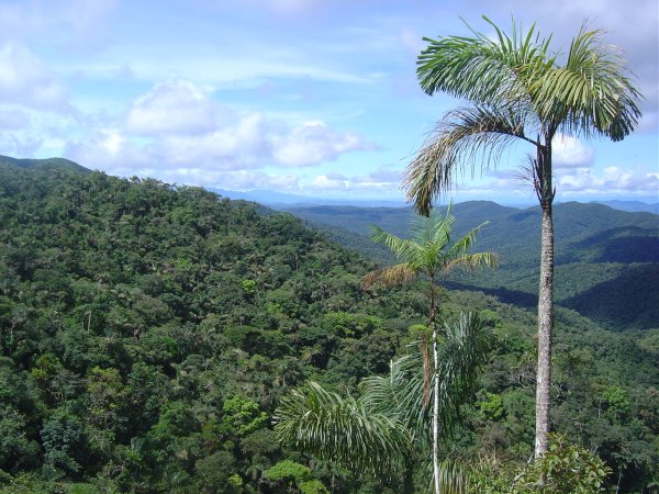
Locality 3: Submontane Pluvial ForestFinally we worked in a zone where the forests were dominated by the Andean palm Dictyocaryum lamarckianum in the upper area about 1200–1600 m and the Oenocarpus bataua in lower areas, 800–1200 m elevation. This locality has the largest, best conserved and most diverse forest of the Apolobamba IMA. This area receives high levels of precipitation and is often covered in fog and the road turns into mud and make it completely impassible during the rainy season.
The forests are very interesting, we hypothesize that the vegetation represent Amazonina elements that have reached these interior Andean area and diversified significantly. We have found numerous endemic species here of genera that are typically Amazonian genera such as Parkia, Hevea, and even the Brazil nut Bertholletia excelsa. Unfortunately the area is gradually being occupied by “colonos” who cut down the forests to grow coca and the future of this ecosystem far from secure even inside a protected area. |

© 1995-2025 Missouri Botanical Garden, All Rights Reserved
4344 Shaw Blvd.
St. Louis, MO 63110
(314) 577-5100
Technical Support