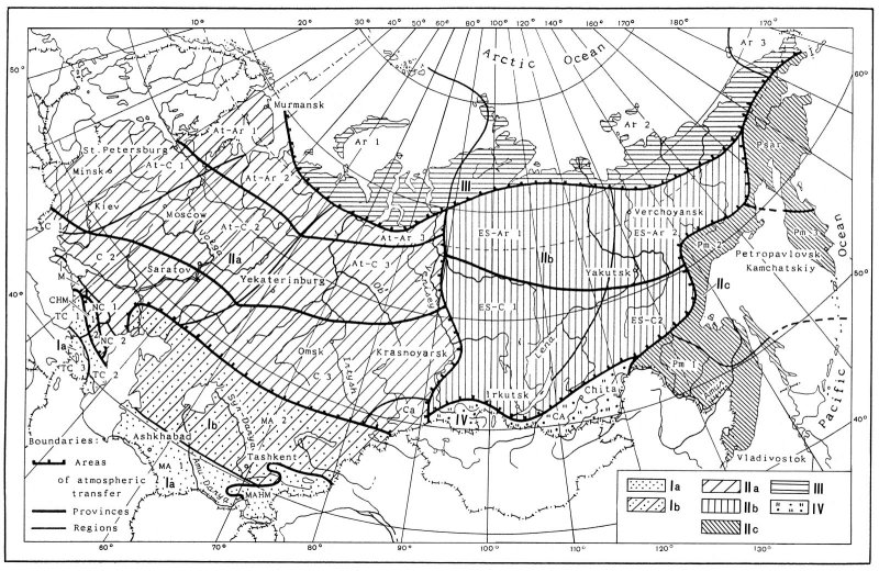
Since some places exist in the FSU where the average annual minimum
temperature is too low for their inclusion in the North America zone 1,
a zone 0 has been added to map 2. Conversely, there are no regions
within the FSU with climatic equivalents to zones 11 or 10.
A warm and mild climate is found in the Caucasus. A very
small area in the southwestern Caucasus, near the city of Batumi,
falls within zone 8 and even to zone 9. Average
temperatures of December, January and February are about 48°
F (9° C); 0° C occurs very rarely and only for
very short periods. The average minimum is ca. 25° F
(-4° C) and the absolute minimum in Batumi was registered as
19° F (-7° C). This area is also remarkable for
its annual precipitation of about 177.3˛ (4,500 mm) more
typical of a tropical rain forest. The climate is obviously warm and
humid.
The coastal area along the Black Sea, from Batumi northward to
Sukhumi, refers to zone 8. Its average January temperature
is 35° F (2° C), with a minimum air temperature
once recorded as 15° F (-9° C). However, cold
periods with a mean temperature of 32° F (0° C)
happen very rarely and last only a short time. Further to the north,
from Sukhumi and Gagra to Tuapse, the temperature is a bit lower and
there is less precipitation, recorded near Tuapse and Sochi as half
that in Batumi. This area can be referred to zone 7.
Another warm place in the Caucasus is the southeastern
Transcaucasus along the Caspian Sea. However, there is a great
difference between the eastern and the western Trancaucasus, and
eastwards the climate changes from humid and warm to one that is dry
and hot. The annual average precipitation in some places in the
eastern Trancaucasus is about 8.1" (ca. 200 mm), which is regarded as
semi-desert, but in some places (e.g. the Lenkoran region), the humidity
is much higher, and during autumn the precipitation can reach 12" (ca.
300 mm) a month. The winter in the eastern Transcaucasus is colder than
in the western regions, and in Makhachkala the January mean is 10°
C/18° F lower than in Sochi, in spite of the fact that both
cities are on the same latitude. A small area near the city of Lenkoran
has a very warm winter, yielding the earliest crops in the FSU. This area
used to be popularly called the "Kremlin Kitchen Garden" because much of
the produce was sent to the Kremlin in Moscow. This southern coastal area
along the Caspian Sea can be referred to zone 7.
The Armenian Highlands in the central part of the Transcaucasus
have a continental type of climate. The average annual precipitation is
about 12-30" (ca. 300-800 mm) at the highest elevations, and 6-12"
(150-300 mm) on the plains. The rainfall reaches its maximum in spring
time, the average mean January temperature is 10° F (-12°
C) in the mountains and the maximum mean in July is 65° F
(18° C). In the Ararat Valley the absolute recorded maximum
is 110° F (43° C), in winter the temperature can
drop to -10 to -22° F (-25 to -30° C), and the
minimum is -26° F (-32° C), with average minimum
mean -11° F (-24° C). Therefore this region’s
climate corresponds mostly to zone 5 but also in part to zones
4 and 6.
In the northern Caucasus, the climate is also a continental one. The
average January temperature in Pyatigorsk is 23° F (-5°
C) with an absolute minimum of -24° F (-32° C); in
Novorossiysk, January averages 34° F (1° C) with an absolute
minimum of 4° F (-16° C). Considering these average
minimum temperatures, this region can be best refered to zone 5 with
only some places to zone 6.
The whole western portion of the FSU lies under the influence
of the Atlantic Ocean, within climatic zone 5, and some southwestern
areas fall into zone 6. One exception is a narrow coastal area in
the southwestern Crimea (or Krym Peninsula). Here, the favorable
weather conditions largely result from the mountains that provide
protection from northern winds. The average minimum temperature is about
17° F (-8° C) in Yalta, and the precipitation is
27.5" (70 mm) in January, and 10.6" (27 mm) in July. The region falls in
zone 7 and some protected places with southern exposure close to
zone 8. Northern and central areas of European Russia are
best referred to zones 4 and 3 with the winter colder to the east
but warmer to the west.
The Asian component of the FSU consists of Siberia, the
Russian Far East and Central Asia that was formerly known as Soviet
Middle Asia. Central Asia includes the republics of Turkmenistan,
Uzbekistan, Tajikistan and Kyrgyzstan, and also the southern part of
Kazakstan. The region can roughly be divided into two regimes. Areas to
the south of 40° latitude are subject to diverse climatic
influences and have particularly variable weather, especially in winter.
In any given place, winter temperatures can range dramatically from
-15° F to 70° F (-26° to 21°
C), and even the average temperatures also range widely. For example,
in Ashkhabad the average January mean can be 22° F (-5°
C) in one year but 45° F (7° C) in the next.
Southwestern Central Asia, mainly southern Turkmenistan, belongs to
zone 6. In the mountainous regions occupying southern soviet
Central Asia, the temperature often depends on exposure. Thus the
January mean near Lake Issyk-Kul’ is ca. 25° F (-4° C),
whereas in Naryn, which is situated 1° degree further south, the
temperature drops to 0° F (-18° C). On the high
mountain plateaus of the Pamiro Alay, the July temperature mean is
60° F (16° C), while the January mean is 5°
F (-15° C). The annual average rainfall is less than 3.9"
(100 mm), indicating that the vegetation in the Pamir is high mountain
desert. Above 40° N latitude, in northern Kazakstan, the
winters are severe but the summers hot. The average January temperature
is about -20° F (-29° C), with minimums to
-40° F (-40° C). Therefore, the northern regions
belong to zones 5 and 4 with some places assigned to zone 3.
Most of Central Asia and Kazakstan is characterized by very hot summers
(up to 120° F, or 50° C) and insufficient moisture
(in some places less than 2.2" or 55 mm per year).
The major portion of Asiatic Russia belongs to Siberia, which is
divisible into two large regions: western Siberia and eastern Siberia.
The winters become more severe from west to east and in both Siberian
regions, minimum temperatures drop to -40° to -50°
F (-45° C). Therefore, these areas belong to climatic zones 2 or
1. The central part of eastern Siberia is even colder, with minimum
temperatures dropping below -50° F (-45° C). In fact, the
cities of Verkhoyansk and Oymyakon are known as the coldest recorded
cities in the Northern Hemisphere, and their winter minima (or lowest
means) to -94° F (ca. -70° C). Only the Greenland
Ice Plateau can match this extreme cold in the heart of eastern Siberia.
No such zone appears among the American "Hardiness zones" these conditions
of such extreme cold simply do not occur in North America. In contrast
Siberian summers are warm, with an average July temperature in the
Transbaykal area of 68° F (20° C) with a maximum
of 95° F (35° C). To the north there are short
summers and long winters, and with snow cover extending for 8 or more
months, permafrost exists despite the rather warm summers. Therefore,
both eastern and western Siberias belong to zones (0), 1 or 2.
However, some areas can be referred to zones 3 or 4 notably, the
Altay and Baykal areas. The climate of the Altay mountains
is unusual due to its sharply contrasts in orographic conditions. The
lowest minimum recorded in some places in the Altay is -45° F
(-43° C), but the January mean can be - 2° F
(-19° C) at Gorno-Altaysk. Summer in the Altay is not as
hot as in neighbouring Central Asia and southern Siberia. The annual
precipitation also differs from that of neighbouring territories,
increasing to 31" (ca. 800 mm) in Altay over a drier Central Asia. The
climate near Lake Baykal also differs from that of most of southeastern
Siberia. The average January temperature near the lake is 15°
F (-9° C), whereas in Verkholensk, a city 105 miles (170 km)
away, the winter is much colder, and average of the same month is
-20° F (-30° C). Moreover, summers around Baykal
are cooler than in southern Siberia and the average July mean in central
Baykal is 50° F (10° C), whereas in the city of
Bargusinsk (only 70 km farther E) it rises to 62° F
(17° C).
The Russian Far East extends from 70° N to
42° N latitudes, exhibiting even greater variety in climates.
The continental landmass, and the Pacific Ocean with the cold current
from the Sea of Okhotsk, both influence the climate. The continental
influence is especially prevalent in winter. Winter in the Russian Far
East is not as cold as in Siberia, but it is much colder than would be
expected from its geographical position. For example, the "Kedrovaja Pad"
reserve, south of Vladivostok, lies at about the same latitude as
Marseille, France, which enjoys a subtropical climate. However, the
January mean at "Kedrovaja Pad", is 10° F (-12° C)
with a lowest minimum temperature of -11° F (-24° C).
The region belongs partially to climatic zone 5 and in mountain areas to
zone 6. The Bay of Olga, which lies on the Sea of Japan at the
same latitude as the city of Tuapse on the Black Sea, has a January mean
of about 10° F (-12° C), which is very much lower
than that of Tuapse, lower even than that of Moscow. These regions to
the north of Vladivostok refer to zones 5 or 4. On the Kamchatka
Peninsula the coldest areas have a January mean of -1° F
(-18° C), with a minimum down to -35° F
(-37° C). Therefore the Kamchatka belongs to zone 3, but
some places such as the Geyser valley belong to zones 4 or 5. The
winters in the Anadyr region are much warmer than in neighbouring East
Siberia with the coldest month being February with an average temperature
of -20° F (-30° C) and a minimum of about
-32° F (-35° C). This northern region belongs to
zones 2 and 3. The Pacific Ocean influence prevails in summer,
especially in the central and southern parts of the Far East, but the
remaining northern portion is under an Arctic influence. Seasonal winds
originating in the Indian Ocean to the south bring heavy rain to all the
Pacific coastal areas, especially in July and August. The annual rainfall
in the Maritime region (or Primorskiy Kray in Russian) is 20-40" (ca.
500-1,000 mm), but in any given place it can vary markedly from 40"
(ca. 1,000 mm) in one year to 136" (ca. 3,500 mm) in the next. Dense
fog is prevalent common along the coast during summer. Sakhalin Island
and the Kamtchatka Peninsula have less severe extremes of climate, than
mainland territories of the Far East. The Pacific Subarctic region
differs greatly from the monsoon region in having much shorter summers.
An average September temperature is already as cold as that in winter
time being of 30° F (-1° C).
To summarize, territories of the FSU fall largely within zones
(0), 1, 2, 3, 4 and 5, with zone 6 seen mainly in the
Caucasus, southern Central Asia, and the southern Far East. Zone 7
falls in the Caucasus and Southern Middle Asia; zone 8 in a narrow coastal
area in the southwestern Crimea and Caucasus (along the Black and Caspian
Seas) with zone 9 noted only along southwestern coastal Caucasus.
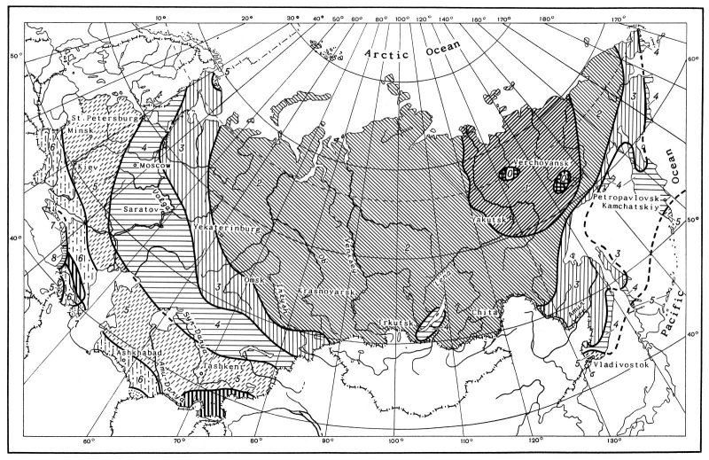
A Hardiness zones map is an invaluable aid to determine under which
conditions plants may be expected to survive winters. It is also
important to know what kind of environmental conditions favor a plant
during its growing season. In this connection the sum of temperatures
is a particularly useful guide and the method was proposed by Reamur
(1683-1757) still widely used in agriculture. Daily temperature means
over 10° C (50° F) are added together to reach a
sum known as the effective temperature. The data given below were taken
from Davitaya & Sapozhnikova (cited from Shulz, 1981) and show the
effective temperature sums for the localities listed.
Summed effective temperature (Celsius scale)
| (a) European part of the FSU |
|
|
City |
Republic |
Summed° C |
| Krasnodar |
Russia |
3500° |
| Astrakhan |
Russia |
3300° |
| Stavropol |
Russia |
3300° |
| Kishinev |
Moldova |
3150° |
| Donetsk |
Ukraine |
3100° |
| Volgograd |
Russia |
2800° |
| Zhytomir |
Ukraine |
2750° |
| Minsk |
Belorussia |
2300° |
| Moscow |
Russia |
2000° |
| Vyatka |
Russia |
1900° |
| Yekaterinburg |
Russia |
1850° |
| St. Petersburg |
Russia |
1500° |
(b) Asiatic part of the FSU |
|
|
City |
Republic |
Summed° C |
| Ashkhabad |
Turkmenistan |
5000° |
| Tashkent |
Uzbekistan |
4300° |
| Almaty |
Kazakstan |
4000° |
| Aral |
Kazakstan |
3400° |
| Karaganda |
Kazakstan |
3100° |
| Semipalatinsk |
Kazakstan |
2300° |
| Biysk |
Russia |
2200° |
| Tobolsk |
Russia |
1600° |
| Ustilimsk |
Russia |
1400° |
|