Red river (Betsiboka)
Click image for enlargement
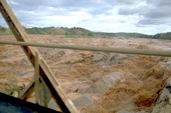
When the rains come to the central highlands, the land is transported away in amazing torrents in which even the froth is red. This view illustrates the severe erosion that is common in Madagascar. Sediments estimated to be 130 feet deep were deposited in the estuary of the Betsiboka River between 1900 and 1950. Such extreme erosion is decreasing the ability of the land to support human needs.


|
Contents:
1.Large moth
2.Plateau village
3.Brickmaking
4.Clearing primary rainforest
5.Disappearing forest
6.Rainforest disappearance map
7.Air view of erosion
8.Red river (Betsiboka)
9.Roadside charcoal
10.Cissus takeover
11.Mananara River gallery forest
12.Poles from Ankarana
13.Galapagos tortoise
14.Reserves and vegetation map
15.Ranomafana entrance station
16.Masoala view
17.Black and White Ruffed Lemur
18.Black and White
Ruffed Lemur call
19.Madagascar Periwinkle
|