
Vegetation is characterized primarily by its physical features, i.e., by its appearance or physiognomy -- whether it is forest, grassland, thicket, etc. However, the map produced by Humbert and Cours Darne (1965) relied heavily on climate and on floristic considerations, such as the presence or absence of certain indicator species (including Myristacaceae, Anthostema (Euphorbiaceae), Tambourissa (Monimiaceae), Weinmannia (Cunoniaceae), etc.); it also included information from geology and soil types.
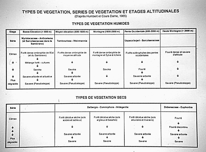
Humbert and Cours Darne (1965) also maintained the concept of altitudinal stages (étages altitudinaux) developed by Perrier de la Bâthie (1921) and Humbert (1951, 1955), which divided the two regions into a number of domains ranging from 0-800 m, 800-1800 m, etc. Furthermore, they applied the concept of dynamic vegetation series (séries dynamiques de végétation) (Gaussen, 1949, 1957, 1958), which attempts to summarize the progression from the climax vegetation, such as rain forest (forêt ombrophile) in the east, through various types of secondary vegetation that form a degradation series resulting from increasing human impact. As a consequence, however, the 1965 map prepared by Humbert and Cours Darne does not represent a true vegetation map, and the inclusion of very different types of information inevitably introduced a certain degree of ambiguity, a fact that has been pointed out by several authors (e.g., Cornet and Guillaumet, 1976).